Voyage Menu
Boats Log

Destination: Cork, Ireland reached safe and sound!!!

Date: 6/30 0530 UTC
Lat: N 51.53
Long: W 8.29
Crew were up by 5:30 AM eating Phil's sourdough pancakes anticipating landfall. We passed through two sailing classes in the inner harbor of Cork, Mirror dingys and Sabots scooting around with tiny leprachauns in them. Picked our way up river to the Marina where we were met by the owner and tied up. Customs were called but never showed up. Geo and Mary cleared off the boat and went to a hotel and Peter and Mari to a B&B. Group met for dinner and retired early - exhausted. More to follow.

[Webmaster note:  According to George and Mary's blog, the 2800 mile trip took 13 Days 9 Hours 20 Minutes.]

Date: 6/30 03:14:30 UTC
Lat: N 51.23.93
Long: W 09.35.69
With the coming dawn passed between Cape Clear and Fastnet Light in calm seas. LOTTO
Date: 6/29 12:00 UTC
Lat: N 51.08
Long: W 12.39
Heading to Ireland via Bombay, COG 080, SOG 10 Kt
Had a wonderful sail y'day during the afternoon and into the evening (183 NM in 24 hr.). A festive mood as we closed on the Celtic Sea. Plans being made to kill the Bombay before we lose it to customs. Peter and Mari sat up till 2300 watching the streaks of light from the northern sunset and seas that resembled molten lead. Air dropped off by 2400 and we went to the iron sail. By 0830 we we put up the 1.5 A-Kite  and started making 10 Kt. on a building breeze. Mary made her infamous "North Atlantic Drift" breakfast and made the crew happy. That was following last nights roast beef and trimmings (we all expected to lose weight on this trip). Severe clear conditions are ushering us into Ireland. We are passing over the Pastouret Spur south of the Porcupine Bank, looking for a Superbouy (ODAS K2) that is maked on the chart. Heading directly to Fastnet Light and subsequent appt. w/any local pub. Everyone's gear strewn around the cabin and mixed w/packs of food, laundry and hardware. The decks are covered w/every imagineable line, rigging, sails. We have a days cleaning to do when we get to shore. George Hot and High Thurtle has kept Rocket Science tuned to squeeze out every possible knot available. It is enjoyable watching him work. Make us go fast George! We wanted to do the crossing in under 14 days but will settle for the same. Crew were issued Campaign Decorations for their part in our Atlantic passage. Phil, who evidently never sleeps, keeps humming "I'd rather die when I'm living than live while I'm dead" we wonder what he has in store for us.
Date: 6/28 15:44 UTC
Lat: N 50.51
Long: W 17.00
Building speed in the dark, Baro: 1012.7, COG: 118 M, SOG: 7 kt, Sunny Day
Our speed built last night on the midnight watch. We saw sustained boat speed of 12 kt, with surges of 14,16,18 kt for three solid hours. More thrills double reefed. It is cold and a little uneasy surfing through the dark with luminescense flashing across wave tops and in our wake. Geo kept it hot and high thru the night. Wrapped the A-kite in the forestay in the afternoon that took a couple of hours of work in v. lumpy seas. Had a bad jibe @ 04:30 that got all hands on deck in 35 kt wind. Otherwise crew resting and "wareing" the boat on different tacks. Got a tie up arranged at the Salve Marina on the Owenboy River in Crosshaven . 2 reef lines pulled out and tore the main a little y'day so will require pulling and trip to a sailmaker. 188 miles ptp y'day. pjm
Date: 6/27 12:00 UTC
Lat: N 50.04
Long: W 22.15
Out of the Fog, into the blue, COG: 097, SOG: 8.0, Baro: 1017.7, Vis: 10 miles
We moved into a weak front and the seas settled all through the night. Winds went from 25 Kt to the current 12 Kt.  Will raise the 1.5 kite the afternoon. We left the fog behind this morning and have some blue skies showing. Silver backed waves race ahead of us reflecting the sun we haven't seen in days, much like home (Juneau).   Geo hasn't caught any fish yet, but we aren't starving.  Have enough provisions for another week.  Planning some big meals before we reach port and have to give up forbidden foods and drink.   Phil is planning hikes and long runs for us all as soon as we land.   Geo, Mari, and Peter are planning a pub tour.   220 miles in the last 24 hr. point to point.
Date: 6/26 13:20 UTC
Lat: N. 49.27
Long: W. 27.31
Das Boat dodging icebergs and looking for U-Boats
Baro: 1021.0, COG: 083 M, SOG: 10.5, Wind 20 Kt NW, Vis: 4 mi in fog
Covered 219 N miles PtP Y'day, in building seas. Hit 16 Kt surfing and flying along. Wind and seas on our stern qtr. @ 20 Kt all night & today, currently 10-12 ft and breaking. Making a little too much Norther will jibe later in better conditions. Hit a bergie bit (ice) last night on the keel. Out of the Gulf Stream into the N. Atlantic current .   Boat rides wonderfully and is dry. She is a dream in these conditions. Saw Arctic Tern y'day . Mary did an incredible job in making a birthday cake for Lisa early this AM. Party postponed till later. Effort required below decks.

Mari looking forward to getting to Cork and meeting a collage chum and returning to USA on the 12th. Geo and Mary plan to return circa the 4th, Peter has a ticket to Alaska on the 8th, Phil and Lisa are picking up the Kids and Phil's sister on the 9th at Shannon, and staying in Ire & BI for a couple of months. Rocket Science will go on the hard in GB later this summer and be sailed next year in Northern Europe.   pjm

no U-boats sighted.

Date: 6/25 14:06 UTC
Lat: N 47.54
Long: W 32.09
Mid Atlantic Ridge, COG: 080 M, SOG: 8.5 Kt, Baro: 1028.7, Vis: 10 miles
Motored out of the high last night and picked up a 20 breeze. During the night made 10-12 Kt consistant racing through silence. Ended up w/195 miles point to point y'day. (120 the day before). Currently doing 9 - 12 Kt in 8 - 10 ft. seas. Haze w/fog on the horizon. 60 degrees. Crossing between the Faraday and Maxwell Fracture Zone of the Mid Atlantic Ridge. Exciting sailing. Planning our arrival. Could not get moorage from Crosshaven marina so may have to try Kinsale , will call both of them when we get closer. Any connections/suggestions out there ?

Crew reading in bunks and napping as it is difficult to not be pitched around the boat. Under 1000 miles left. Mary looking good on the Lotto today. pjm

Date: 6/24 16:31 UTC
Lat: N 46.35'
Long: W 36.06'
Trying to outrun the high, Baro: 1032.3, COG: 102, SOG: 7.5 Kt
Yesterday evening the tack parted on the A-kite, all hands on deck to snuff it. Set up with the roller furler jib after that. Wind dropped through the night, boat started wallowing in confused seas. C. 0500 hrs. we started the engine, with winds light and coming directly over our stern. From surface charts we have determined that the high is following us and expanding northeast. As we are unable to out sail it at this point we have turned on the engine and are hoping to outrun it to the east.

Thick fog rolled in early this morning, visibility down to about 1/8 mile. Phil's repair to the watermaker failed last night, so Crew is getting used to the idea of saltwater showers taken off the stern. Mari reconsidering round-the-world cruise on Andiamo. Numerous Crew members have approached Peter re. changing their ETA to Fastnet Light , Peter's holding firm (maybe since he predicted the latest time in). mcc

p.s. learned yesterday the State of AK is blocking Rocket Science's website. Hey Bianca, you have some pull w/Beth, help a sister out.

Date: 6/23 16:23 UTC
Lat: N 45.57.35
Long: W 39.18.31
Fastnet Funtime in the Fog, COG: 039, SOG: 7.1, Baro: 1032, Current Vis: 6 mi
We immeadiately knocked on wood when Phil sighed and declared that there were more systems now fixed than there were broken. But not hard enough. Spectra imploded last night taking out the pre filter, Phil may have a jury rig this afternoon. Otherwise hand pumping will be the order of the day. Pwr. winch crapped out, whacked the relay a few times and it is now functioning for the moment, Nobeltec keeps crapping out, loading a spare computer with a backup to run the Nav. In the meantime U Plotting sheets are fine and fun to do.

Am worried about some of the Crew staring out over the foggy waters like they are looking for a homeland. Fog has lifted a bit today, but usually gets thick in the late afternoon. Everything sticky and damp. Motoring last night and prob. tonight. Trying for kindly Lat & Long with wind. Finally changed tack for the first time in the trip. Saw 2 ships a couple miles off, we are not alone - as we were beginning to suspect. Above decks the boat is a thrill to sail and is top notch on the wind. We have used about 6 of the 11 sails on board. We are crossing the Milne Seamounts and looking for some company. Xferred 20 gal. of fuel from jugs to tanks last night (We have 170 gal. OB). pjm

A-kite update:

Put up the 2.2 kite and brought the boat to wind speed. Zephered along at 8 Kt for the afternoon with the wind falling to 4 Kt Struck the sail @ 8 PM. Will try the 1.5 today as winds are down.

Fastnet Light Lotto

OK you have asked for it....Crew have chosen their ETA for Fastnet Light (even though I think it is bad luck)

Mary 6/29 @ 9 P.M. (Wishful Thinking Mary)
Mari 7/1 @ 5:07 A.M. (0h sure Mari)
Lisa 7/1 @ 2 A.M. ( She said with a twinkle in her eye)
Geo 6/29 @ 2300 (George knows....)
Peter 7/3 @ 6 A.M. (Been there...shit happens)
Phil 7/1 @ 2 P.M. ( Captain Phil)

Seamounts - click to enlarge
Date: 6/22 22:06 UTC
Lat: N 45.27
Long: W 43.12
Entering the Newfoundland Seamounts, COG: 109, SOG: 9.6, Baro: 1031.1
Thick fog all night as we traversed under the Flemish Cap. No shipping sighted for 3 days. At the end of the night watch the winds dropped to nothing & seas calmed out thru the night ( 186 miles in 24 hr.) and we started motoring into the North Atlantic Current. Water temps up to 68 degrees now and fog has backed off to horizon for the moment. Vis 2 miles. The water temps started rising @ 0400. At 0715 picked up a large bundle of 1/2 inch polypro line in the prop and rudder. The prop spurs cut the line and it took some doing to get it off the rudder. Appears no damage was done to the prop shaft.

New Spectra Watermaker (mod. Santa Cruz) functioning at 1/4 capacity, suspect air lock issue. Some fuel leakage traced to inspection port. Nobeltec Nav keeps crashing. May be a ram issue. Reformatted the HD on the computer and it is working better. Water leaking into sail locker will be tackled today. All good activities to keep Phil busy.

Attention Ladies and Gentlemen, we are now entering the Newfoundland Seamounts , on your right you have the Newfoundland Basin , to your left just over the horizon about 500 miles is Greenland. Mary is counting the days to Ireland (8?).   Phil and Lisa miss the kids. Geo continues to make this rig go fast and is planning to fly the 2.2 asymetrical kite in a while.

Alls well. gt/pjm

Date: 6/21/06 14:35 GMT
Lat: N 45.01
Long: W 48.12
Summer Solstace, SOG: 9.5 Kt, COG: 094 M, Baro: 1027.2, WS: 15 Kt
Off the Grand Banks, moving into deeper water, seas settled a bit. Thick fog and gunmetal grey seas, an occasional petrel flys by. Getting a bit colder, like sailing in SE Alaska. Challenging getting around the boat, reading and typing so not much activity. Watermaker not making, due to heel of boat, on short rations. Perishables perishing. Everyone eating well for the moment. Ordered a new WX report, expect a forecast and vectoring in a few hours. Night watch is cold and wet, grim in the fog. Everyone bundles up and clips into lifelines when on deck. Forward berth unusable in rough seas, sharing bunks and holding tight. Maintaining a close stbd. reach. Holding off on flying the A-kite until we can see the bow of the boat. Hope to be out of fog tomorrow. Many thanks to Scotty Hurlbert for doing our web page and updating for us/you. We are off the charts!, using universal plotting sheets. pjm/mcc/pvm
Date: 6/21/06 01:00 GMT
Lat: N 44.53
Long: W 51.01
On the Grand Banks, heading South of Flemish Cap, COG: 107, SOG: 9.7 Kt
On the Grand Banks, Vis 1/4 mile in h. fog, seas 7-9 ft, & confused, winds 20-25k. Double reefed Main, heading for s. of the Flemish Cap expect to enter a hp area, better seas. Some Crew under the weather. 24 hr distance 220. pjm
Date: 6/19/06 18:47 GMT
Lat: N 44.24.86
Long: W 57.29.46
Crossing the Gulf of St. Lawrence, COG: 097 M, BSP: 7.5 Kt
Starting our crossing of the entrance to Gulf of St. Lawrence. Fog - vis. 400 yds. Glued to radar, many thanks to Wade and crew of Medeia for the training on the scope. Our first change of sail this morning rigging the Code Zero, Geo. cranked out an extra knot with that. Made 200 mile days in light air since we left Cape Cod. Saw Flipper this AM and occasional whales. Boat at 15-20 degree heal - water ballast working after Phil and Geo put in many hours of work. Spit showers the order of the day. Water maker doing full duty. SSB down - ergo no WX fax. Looking to do movie night w/popcorn. Commander Weather advises up to go to N45, W45 and check in for outlook, stay low away from ice, sorry Phil ! Peter and Mari reciting Peter has this one memorized' target='_new'>memorized poems(link uncensored) to each other. Mary looking forward to . Lisa is busy with watch and thinking about the kids. LED lighting works great. Buzzed by Canadian fighter jets. pjm
Date: 06/18/06 14:00 GMT
Lat: N 43 41 34
Long: W 62 49 21
CR: 090, BSP: 9.4 Kt, Baro: 1020, Weather Clear Sunny, 80mi off Sable Island
Fog last night, thick. Close passage w/ 2 large ghost ships. Moving along smartly at 9 Kt this AM close reaching at 60 degrees. Whales : Orca pods. We're 80 ish miles from Sable Isl. and a more easter course chg. pjm
Date: 06/17/2006 20:40 GMT
Lat: 43.87.83 N
Long: 65.40.48 W
Our first night sailing was a gift: Baro: 1018.4, COG: 90 degrees, BSP: 9.2 Kt
10 Kt steady winds and we avg. 8 Kt all night. Darkness followed by surprising moonrise @ 2 A.M. Very cool in the evening everyone in polypro/fleece. Only a couple of ships spotted today. Sword Fishing boats prowling around. 3-4 foot swell all dayand picked up speed to 9 Kt avg. with Main, Jib, and Trisail. Off the tip of Bay of Fundy, getting influence of flood currents. Phil is quite 
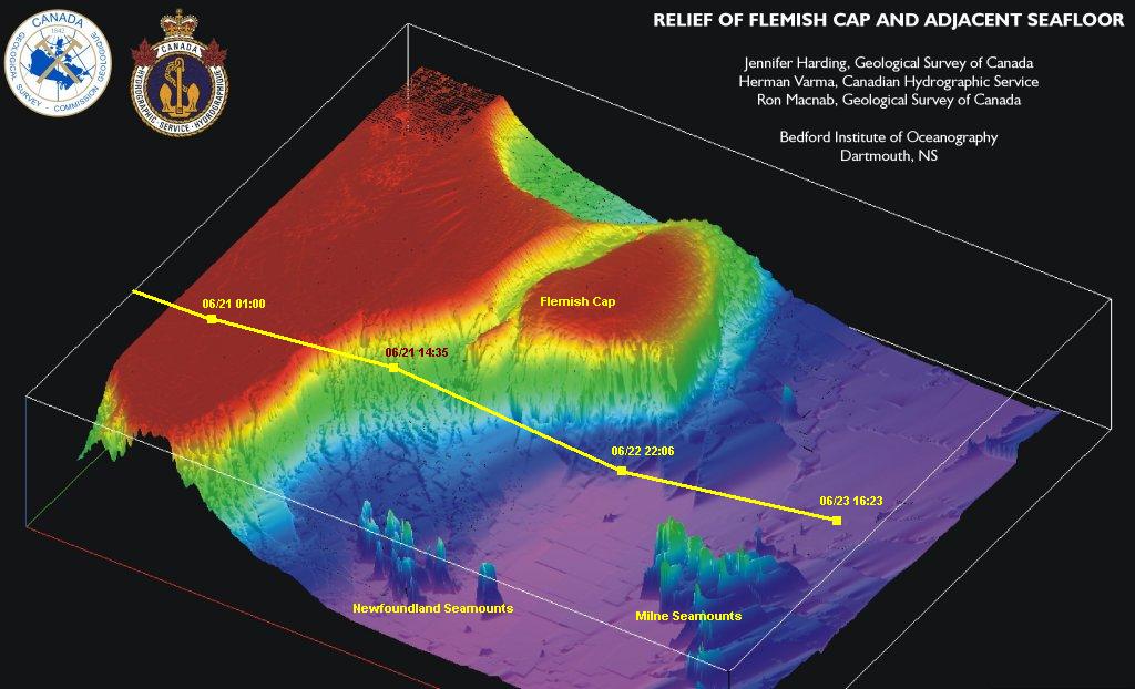
happy to be going north to join a great circle route E. of Sable Isl. He is looking for icebergs to wrestle. Mari is getting over an accidental mis-dosage of seasickness meds and has slept the last 24 hours, but now is doing handstands on the deck. Geo. keeps adjusting sail for max drive. Lisa and Mary are working on projects, and standing watch. We are running the engine for 45 min. 3x daily to keep up the bank of batteries for electronics, reefer, and auto helm. The solar panels that Mari hooked up are putting out 15 amps 20 volts during the day, enough to keep up with the auto helm. Chicken Marbella last night. pjm
Date: 06/16/2006 06:46 GMT
Lat: 42.10.79 N
Long: 69.39.92 W
Baro: 1015.8, COG: 66 mag, BSP: 7.5 Kt, Heading for N 44 x W 60
Departed Cuttyhunk @ 10:45 GMT Motored to the Cape Cod Canal where we were met by 6 Navy Minesweepers exiting canal. Passed through the canal @ 11.5 Kt on the flood. Upon entering Gulf of Maine we entered severe calm seas. Motored 7 hours, till 8 Kt breeze started up just outside of the shipping lanes. Commander Weather recommended we head for N 44 x W 60 off Sable Island for proper winds. Geo. seems to have a bone in his teeth trimming the sails. Set up watch schedule, plotted great circle route. Systems functioning pretty well. SSB yet to perform. Geo is dragging a fishing line. All is well. pjm
Date: 06/15/2006 06:30 GMT
Lat: 41°25’52” N
Long: 70°54’08” W
Left Cove Haven @ 11:30 EST for Buzzards Bay
Left Cove Haven @ 11:30 EST for Buzzards Bay to stage for the Cape Cod Canal. Sailed most of the way to an anchorage - Cuttyhunk Ma. outside of Woods Hole. This is a perfect place for pirates and rum runners. We are going to catch the flood @ 7:30 A.M. The tide runs @ 4.5 Kt @ max flood in the canal. We are going directly offshore tomorrow. Had the boat going 8-9 Kt today with just the main and jib. We expect to do better when we put up the kite. Our electronic water ballast system is working well for now. SSB hasn't been up and running yet. Crew is quite excited and having a big night of it. Lines and rigging are in order. pjm
Date: 06/14/2006 19:13 GMT
Lat: 41°45’56” N
Long: 71°21’00” W
All fueled up with nowhere to go
The boat is ready as we are. We have been tracking the weather through a forecaster at Commander's Weather. Our plan is to leave on the Thursday noon tide and go to the Cape Cod Canal. Pass through Friday morning up to Provincetown Ma. and see how the storm has tracked. We will go offshore either on Friday or Saturday. pjm
Date: 06/14/2006 00:56 GMT
Lat: 41°45’56” N
Long: 71°21’00” W
Tuesday 6/13: We're following the course of the storm, and hoping to cast off Thursday noon. Meanwhile there are plenty of projects on the boat. Peter and I learned the proper way to flake an asymmetrical spinnaker first thing in the morning. Mary sewed the "sailcar" (the piece that feeds into the track) onto the mainsail, very important in keeping the main attached to the mast. George taught Peter and I how to raise the 2.2 oz. reaching spinnaker, and Lisa kept organizing provisions to make sure we have food mid-Atlantic.   Peter and I checked out the boats in the harbor, and have decided to go for the Alerion we saw, a sweet little Herreshoff sloop - at only $250K we think it's a good deal. Input would be appreciated. Mari
Date: 06/12/2006 21:04 GMT
Lat: 41°45’56” N
Long: 71°21’00” W
Well we are ready to leave . ETD is tomorrow, AND we have a hurricane coming up from Florida. Do we leave in the face of it or wait? Tell me, you decide. You probably want us to get the show on the road eh? Nice as it is here in Barrington, I am ready to leave and stop all the boat projects and get going. Well, we will wait and see what the forecaster (Commander's Weather) says tomorrow. In the meantime there are many tasks to do on a 55' boat, we are working 14 hours a day. George and Phil have fascinating conversations on ball valves, sensors, center of effort etc. while Mari has all the potential party boats sussed out and I feel that everyone is working well together, although I am staying close to Mari. Since Lisa has arrived there has been a flurry of organization going on around the boat and Mary is the greatest Crew person we have doing everything and anything that is needed to be done. pjm
Date: 06/09/2006 23:26 GMT
Lat: 41°45’56” N
Long: 71°21’00” W
Today was spent bending on the sheets and fixing some of the electronic jitters that have appeared. Mary's calm enthusasism is a good balence to Phil's drive to get going. We have an account at the local West Marine and are drawing on the local trademen for all sorts of final repairs. It was muggy today and Vis was about 1 mile in fog. We are doing sea trials tomorrow and expect high winds and rain. Mari rewired two large solar panels and Geo. solved some of the system questions. Our IMARSAT C has tanked.
Date: 06/08/2006 13:46 GMT
Lat: 41°45’56” N
Long: 71°21’00” W
Cove Haven, bad weather with gale force winds may have to wait to depart till 6/13.
Date: 06/04/2006 15:32 GMT
Lat: 41°45’56” N
Long: 71°21’00” W
S/V Rocket Science is at Brewer Cove Haven Marina in Barrington Rhode Island on Narragansett Bay. Est. Departure 6/12